Japanese Gallery (Honkan) Room 16
June 8, 2010 (Tue) - July 11, 2010 (Sun)
This exhibition, the fourth in a series entitled Travelling Japan on Foot, introduces the Tokai region which spans the prefectures of Shizuoka, Aichi, Gifu and Mie. In the past, the region was home to the now-defunct provinces of Izu, Totomi, Suruga and Mikawa, and was intersected by the historically important Tokaido highway, which is illustrated in two works featured in this exhibition.
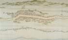
The first of these, the Map of the Five Highways, was produced by the Edo government and is now designated as Important Cultural Property. The map is comprised of numerous large handscrolls which were produced in color to a scale of 1:1800. Minutely detailed, they provide a realistic representation of the highways of Japan at the time of its production.
The second is the Fifty-Three Stations of Tokaido Highway folding screen. The dormitory "stations" along the Tokaido highway began to be designated in 1601 by the shogun Tokugawa Ieyasu. Kawasaki station, the last to be designated, was established in 1623. Many famed sites and ruins could be found along the Tokaido highway, and these were often depicted in literature and poetry.
In the Edo period (1603-1868), the Tokaido stations were maintained to support the travel of feudal lords under the sankin kotai system, which required them to leave their domains periodically and reside in the capital. This system, along with the popularity of pilgrimages to Ise shrine among the commoners of the time, turned the highway into a bustling thoroughfare. Growing interest led to the emergence of decorative paintings with the Tokaido highway as the subject, such as this screen.
We hope these works will help viewers to imagine the historic face of the Tokaido highway.