Japanese Archaeology and Special Exhibition (Heiseikan) Thematic Exhibition Room
June 24, 2014 (Tue) - August 17, 2014 (Sun)
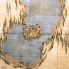
Born near the current Kujukurihama beach, Ino Tadataka (1745-1818) was adopted into a merchant family in Sawara (now Sawara, Katori-shi, Chiba prefecture). While making great efforts in the running of the family business, he enjoyed studying astronomy, geography and mathematics. After retiring at the age of fifty, Tadataka went to Edo (present-day Tokyo) and learned astronomy and surveying methods comprehensively under Takahashi Yoshitoki, an astronomer at the shogunate's office of astronomy. Endeavoring to confirm the exact length of one degree of the earth's latitude, Tadataka surveyed the land of Ezo (present-day Hokkaido) in 1800 virtually on his own. His survey project and the resulting map he created attracted the attention of the Edo shogunate government. Later, at the government's command, Tadataka spent most of his remaining lifetime surveying the land throughout Japan. In 1821, after Tadataka's death, The Great Map of Japan, a map of the whole of Japan drawn as an outcome of his survey, was submitted to the shogunate government.
Tadataka's maps are categorized into ones that are large, medium or small, depending on the level of scaling. The map submitted to the government was lost in a fire in the Meiji era. However, other fine maps of Japan in different scaling, which were created by Tadataka and his associates at various times, are in the collection of the Tokyo National Museum. Visitors can compare the maps that were created by Tadataka himself.
This exhibition introduces representative examples of Tadataka's maps and maps created before him, as well as survey-related documents of the Edo period. It attempts to reveal the elaborateness and beauty of Tadataka's maps, shedding light on a part of the Edo-period culture concerning maps.