Japanese Gallery (Honkan) Rooms T1 & T2
February 14, 2012 (Tue) - March 25, 2012 (Sun)
While looking at maps, many of us have no doubt tried to imagine what it is like in unfamiliar lands, or of actually traveling to those places. At the same time as being a tool for us to perceive the space in which we live, a map can also be a window on an unknown world. When Japan began its contact with European countries and entered the Edo period (1603 - 1868), the previously ill-defined shape of the Japanese archipelago was determined with ever greater accuracy. People also learnt about the shape of the world through maps.
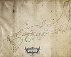
The Great Map of All the Countries of the World, which came via China, and the sheepskin parchment Nautical Chart of Japan are products of this time. In addition, techniques were devised to create maps that were not only records of information, but were also easy to understand and attractively presented. Together with the achievements of print culture, maps spread throughout the general populace. The bird’s-eye perspective of towns found in road maps of this time is still a feature of today’s maps.
This exhibition displays maps created or kept in Japan from the end of the 16th century to the end of the Tokugawa shogunate (mid-19th century), and illustrates changes in the ways of looking at Japan and the world.