Maps of the Edo period
-
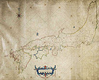
Nautical Chart, Japan, Edo period, 17th century (Important Cultural Property)
Japanese Gallery (Honkan) Rooms T1 & T2
February 14, 2012 (Tue) - March 25, 2012 (Sun)This exhibition displays maps created or kept in Japan from the end of the 16th century to the end of the Tokugawa shogunate (mid-19th century), and illustrates changes in the ways of looking at Japan and the world.
Current exhibit includes:
Map of the Nikko Kaido Highway, Senju, Sosenji, Soka, Koshigaya and Osagamifudo, Edo period, dated 1806 (Important Cultural Property)
Great Map of All the Countries of the World, Edo period, 18th - 19th century (Gift of Dr. Yurugi Ryohei)