Japanese Gallery (Honkan) Room 16
May 27, 2008 (Tue) - July 6, 2008 (Sun)
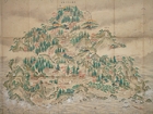
The Tohoku region, or the northern part of Honshu island, Japan, was called Ou or Oshu from the names of the ancient provinces located in this region. These were Mutsu province on the Pacific side and, separated by the Ou Mountains, Dewa province on the Japan Sea side. The region could be also divided into north and south Tohoku. In the south, during the Nara period (710-794) the Mutsu provincial government seat was located at Tagajo Castle, present day Tagajo city, Miyagi prefecture, and had a close connection with the central government in the Kinai region (Nara and vincinity). In the north, the influence of the central government was weak, and the area was inhabited by the Oshu Fujiwara clan and Fushu (northerners who had been subjugated to the central government).
This display features items introducing aspects of the geography, history and culture of this vast region, such as maps of the Oshu region, Drawings of the Golden Hall of Chusonji and Story of Gosannen War in Oshu, as well as travelogues and related literary works.
This display features items introducing aspects of the geography, history and culture of this vast region, such as maps of the Oshu region, Drawings of the Golden Hall of Chusonji and Story of Gosannen War in Oshu, as well as travelogues and related literary works.