Maps of Japan by Ino Tadataka
-
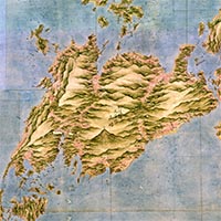
Map of Kyushu (Large-scale map), No. 19 (detail), By Ino Tadataka, Edo period, 19th century (Important Cultural Property)
Japanese Archaeology and Special Exhibition (Heiseikan) Thematic Exhibition Room
October 14, 2015 (Wed) - December 23, 2015 (Wed)Born near Kujukurihama in present-day Chiba prefecture, Ino Tadataka (1745–1818) was adopted into a merchant family in Sawara. After retiring at the age of fifty, he surveyed the land of Ezo (now Hokkaido) in 1800 almost entirely on his own. His survey and the resulting map attracted the attention of the government, which employed his to survey the entirety of Japan – an endeavor he dedicated the remainder of his life to. In 1821, after Tadataka's death, The Great Map of Japan, which was the culmination of his efforts, was submitted to the government. In addition to superb examples of Tadataka's work, this exhibition will also feature maps of Hokkaido by Imai Hachikuro and a world map.
Including:
Map of Japan (Medium-scale map), Eastern Hokkaido, By Ino Tadataka, Edo period, 19th century (Important Cultural Property)
Map of Rebun and Rishiri Islands, By Imai Hachikuro, Edo period, 19th century (Important Cultural Property)